

Quick answer
Mount Toubkal rates as a moderate-to-challenging non-technical trek, demanding solid cardiovascular fitness rather than climbing expertise. The 4,167-meter altitude creates the primary difficulty—roughly 40% less oxygen than sea level—while steep scree sections and 1,400-meter elevation gain test endurance over two days. Most fit hikers complete the ascent successfully, though altitude sickness affects approximately 25% of climbers who don't acclimatize properly, and the final summit push involves sustained effort at oxygen-depleted elevations.
The Toubkal ascent claims no victims to technical difficulty—the route involves walking, not climbing—yet the mountain filters participants through physiological thresholds that fitness alone cannot always overcome. Altitude begins its work the moment trekkers leave Imlil village at 1,740 meters, and by the time the Toubkal Refuge appears at 3,207 meters, bodies are processing oxygen at reduced efficiency. The true test arrives during the pre-dawn summit push, when legs must drive upward through steep scree slopes while lungs work against thinned air. Assessing Toubkal's challenge requires separating its components. The physical demand resembles a strenuous day hike extended across two days: the Imlil-to-refuge section covers roughly 4.5 hours of steady uphill walking, while the summit day adds another 3-4 hours of ascent through progressively demanding terrain. Scree fields above 3,800 meters require careful foot placement—two steps forward sometimes yields one slide back—and the gradient steepens as the path approaches the rocky summit plateau. No ropes, no scrambling, no exposure to fatal falls, yet the cardiovascular system operates at maximum sustainable output for extended periods. The altitude factor distinguishes Toubkal from lower mountains that might demand equal physical effort. At 4,167 meters, atmospheric pressure drops to roughly 60% of sea-level values, forcing hearts to pump harder and breathing rates to increase. Acclimatization becomes the variable separating comfortable summits from miserable struggles—trekkers who spend a full day at the refuge before their summit attempt generally fare better than those who rush the ascent. Acute mountain sickness manifests as headache, nausea, and profound fatigue in a significant minority of climbers, particularly those ascending from coastal elevations without interim altitude exposure. Winter conditions transform the assessment entirely: snow and ice above 3,500 meters introduce technical elements—crampons and ice axes become necessary, not optional—and temperatures plunge to minus 15 degrees Celsius on summit mornings. The summer season (June through September) presents the standard non-technical challenge, where fitness, acclimatization discipline, and mental persistence determine outcomes. The question of difficulty ultimately resolves to personal baselines: a runner accustomed to elevation training may find Toubkal strenuous but manageable, while a lowland hiker of average fitness will likely find it the hardest physical challenge they've undertaken.
“The mountain filters participants through physiological thresholds that fitness alone cannot always overcome.”
How Difficult Is It to Climb Mount Toubkal: The Route Broken Down
The standard Toubkal ascent follows a two-stage route: a 5–6 hour trek from Imlil village to the Refuge du Toubkal at 3,207 m, then a 3–4 hour pre-dawn push to the 4,167 m summit. Most climbers spread this over two days with an overnight at the refuge.
Trek Imlil to Refuge du Toubkal
Start from Imlil village (1,740 m) and follow the mule track through Aremd and up the Mizane Valley for 5–6 hours. The path is clear but relentlessly uphill; many underestimate the altitude gain and arrive at the refuge exhausted.
Rest and acclimatize at the refuge
Arrive by early afternoon, hydrate, and eat a full meal. People who skip proper rest or sleep poorly often struggle with headaches and nausea during the summit push.
Begin the summit push before dawn
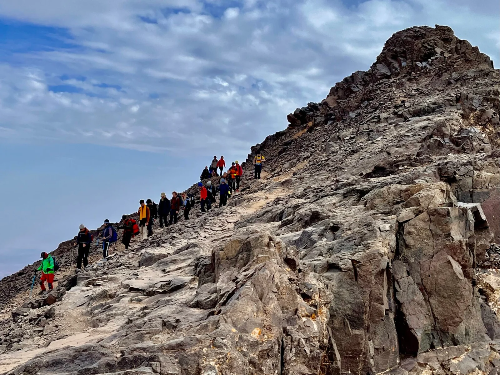
Leave the refuge between 04:00–05:00 to reach the summit by sunrise. The first hour crosses scree slopes in darkness; headlamps are non-negotiable, and loose rock causes frequent slips.
Ascend the south cirque to the col
Climb steep scree and occasional scrambling sections to reach the south col at ~3,900 m. This is where the route steepens sharply and many turn back, mistaking the col for the summit.
Navigate the summit ridge
From the col, follow the rocky ridge northwest for 45–60 minutes. Exposure increases on both sides, and verglas (thin ice) can form even in summer, making the final pyramid slippery without microspikes.
Descend the same route to Imlil
Retrace your steps to the refuge, then continue down to Imlil, typically completing the descent in 4–5 hours. Knee strain is common on the long downhill; trekking poles absorb impact that many first-timers regret ignoring.
How Difficult Is It to Climb Mount Toubkal: Key Numbers Behind the Challenge
The numbers behind Mount Toubkal explain its reputation better than any description: this is a high-altitude walk-up, not a technical climb, but the elevation itself is the main obstacle.
4,167 meters is the summit height
Toubkal's peak sits at 4,167 m (13,671 ft), making it the highest point in North Africa and the wider Arab world, well above any peak in the Alps outside a handful of giants.
1,740 meters is Imlil's starting elevation
Most treks begin in Imlil, around 1,740 m, meaning climbers gain roughly 2,400 m of elevation over the full route to the summit.
3,200 meters is where the refuge sits
The Toubkal Refuge (also called Refuge Les Mouflons), the standard overnight stop, sits at approximately 3,200 m, leaving a final push of about 900-1,000 m to the top.
900 meters climbed before breakfast
Summit day typically starts before dawn from the refuge, gaining roughly 900 m over a few hours on loose scree and rock, the steepest sustained section of the entire trek.
4,000 meters is where altitude effects begin
Above roughly 4,000 m, reduced oxygen availability can cause headaches, fatigue, or nausea in unacclimatized climbers, even though Toubkal requires no ropes or technical gear.
2,400 meters of total elevation gain
From Imlil to the summit, the cumulative ascent is about 2,400 m, comparable in scale to climbing from sea level to well above most European mountain refuges in one continuous trip.
1 of Africa's Seven Second Summits
Toubkal is sometimes grouped among Africa's notable non-volcanic high points, distinct from Kilimanjaro, because its difficulty comes from altitude and terrain rather than any technical climbing grade.
How Difficult Is It to Climb Mount Toubkal in Winter vs Summer
Late spring and early autumn (May-June and September-October) offer the most balanced conditions, with the summit gully largely clear of hard snow but daytime heat still manageable for the exposed scree slopes.
June to September
Busiest, especially August weekendsSnow-free, days 15-25°C, nights near freezing
The final approach is a non-technical scramble on loose scree and rock, no crampons or axe needed, though afternoon cloud and thunderstorms build quickly.
November to April
Quiet, mostly experienced mountaineersSnow and ice above 3,000m, summit days -5 to -15°C
The last few hundred meters to the summit turn into a proper winter mountaineering pitch requiring crampons and an ice axe, and short daylight hours compress the climbing window.
May and October (shoulder)
Moderate, mixed skill levelsVariable, lingering snow patches, 0-10°C at altitude
Conditions swing year to year, some seasons still need crampons through May while others clear early, so checking recent guide reports before departure matters more than the calendar date.
Early morning starts (05:00-07:00)
——
Setting off in this window keeps climbers off the summit ridge before afternoon cloud rolls in and before snow softens on descent, which matters most in shoulder and winter months when the gully is icy at dawn and slushy by midday.
Verdict: For the easiest non-technical climb, aim for mid-June to mid-September with a 05:00-07:00 start; outside that window, treat the route as a winter mountaineering objective requiring crampons and an axe.
Common Mistakes That Make Mount Toubkal Feel Harder Than It Is
Most climbers who struggle on Toubkal make avoidable errors in pacing, gear, or acclimatization rather than facing genuine technical barriers. Correcting these mistakes transforms the climb from a survival ordeal into a manageable high-altitude trek.
Racing straight to the summit without sleeping at the refuge
Sleep one night at Refuge du Toubkal (3,207 m) before your summit push. Your body needs 12–16 hours to adjust to altitude, and skipping this rest doubles your risk of headaches and nausea.
Wearing trail runners or soft hiking boots on summit day
The final 900 m is loose scree and sharp rock that shreds soft soles and twists ankles. Use stiff-soled boots with ankle support and deep tread.
Starting the summit push after 07:00
Cloud rolls in by midday, obscuring the route and dropping temperatures. Leave the refuge between 05:00–06:00 to summit in clear conditions and descend before weather turns.
Packing only a fleece for a summer climb
Summit temperatures drop to -5°C even in July, and wind chill cuts deeper. Carry an insulated jacket, gloves, and a windproof shell regardless of valley heat.
Assuming fitness alone compensates for altitude
Even marathon runners feel altitude above 3,000 m. Walk slowly, breathe deliberately, and accept that your usual pace will halve—pushing through oxygen debt leads to acute mountain sickness, not faster summits.
Preparing for the Difficulty of Mount Toubkal: What to Arrange Beforehand
Addressing these logistics weeks ahead removes the barriers that turn technical simplicity into practical difficulty.
-
Arrange a licensed guide (mandatory above 3,000 m) — National park regulations require a registered guide for all summit attempts, and solo hiking is prohibited.
-
Book a refuge bed for night one — The two mountain refuges fill quickly in peak season, and wild camping is restricted in the national park.
-
Train on 6–8 hour hikes with elevation gain — Conditioning your legs and lungs for sustained uphill effort directly reduces summit-day fatigue and altitude symptoms.
-
Pack crampons and an ice axe (winter/spring) — Snow and ice on the final pyramid demand technical gear; summer scramblers can skip this.
-
Confirm your guide arranges the park permit — There is no gate fee, but the Toubkal National Park permit (handled by your guide) is required for legal access.
Getting to the Mount Toubkal Trailhead Before You Climb
Mount Toubkal's trailhead sits at Imlil, a village in the High Atlas about 65 km south of Marrakech. The standard approach is a road transfer from Marrakech to Imlil, followed by a walk-in on foot to the higher trailhead points.
Marrakech to Imlil via the R203 mountain road through Asni
Grand taxi from Marrakech's Bab Er Robb station to Imlil
Imlil to Sidi Chamharouch via the main valley trail
Sidi Chamharouch to Toubkal Refuge
Villages Near Mount Toubkal to Acclimatize Before the Climb
Two villages inside Toubkal National Park double as staging points where climbers spend a night before the summit push, giving lungs and legs time to adjust to altitude before the harder ground above.
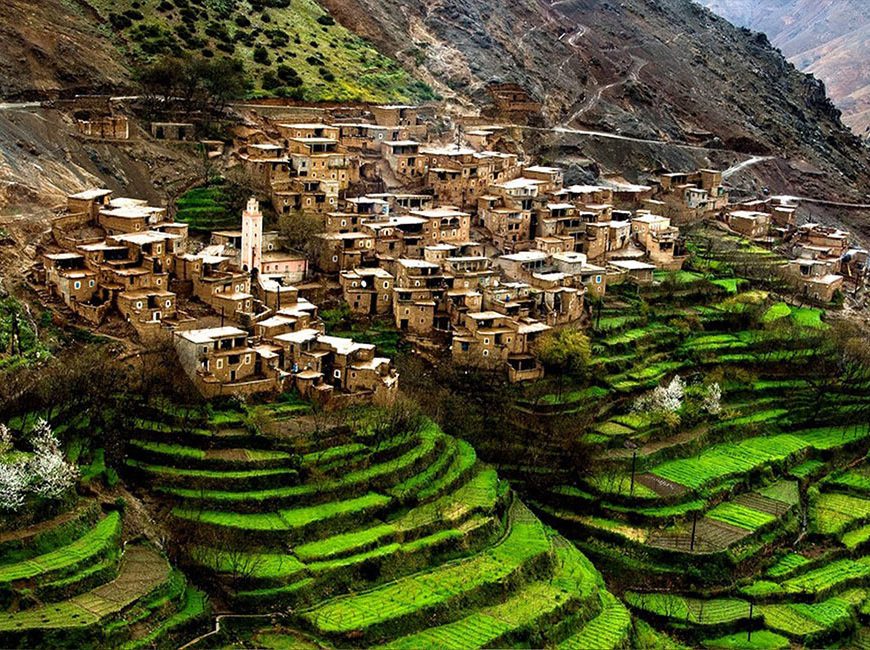
Imlil
Trailhead village at roughly 1,740 m where most itineraries base for a night, letting arrivals settle before the walk-in to the Toubkal Refuge.
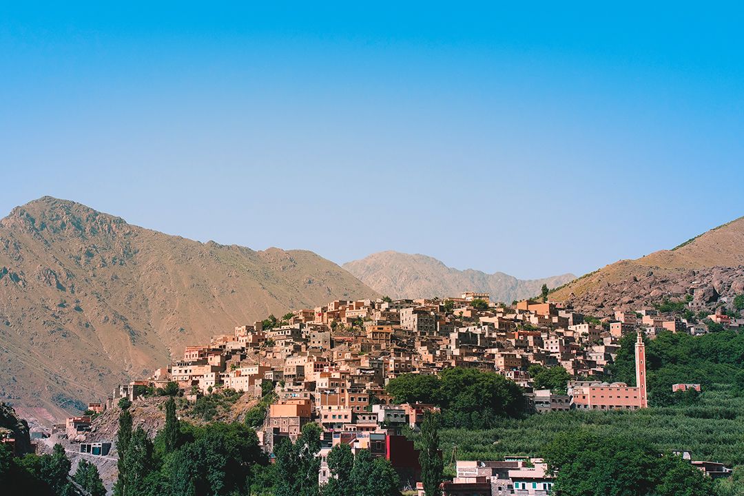
Aroumd
Higher Berber village on the route toward the refuge, useful as a lunch or overnight stop to spread the altitude gain over two stages instead of one.
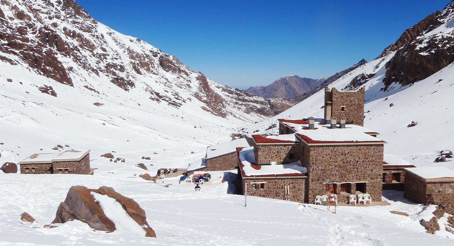
Toubkal Refuge (Refuge du Toubkal)
Base camp at about 3,207 m where climbers sleep before the early summit push, the last acclimatization stop before the final ascent.
Check availability
FAQ: How Difficult Is It to Climb Mount Toubkal
Everything you need to know about how difficult is it to climb mount toubkal